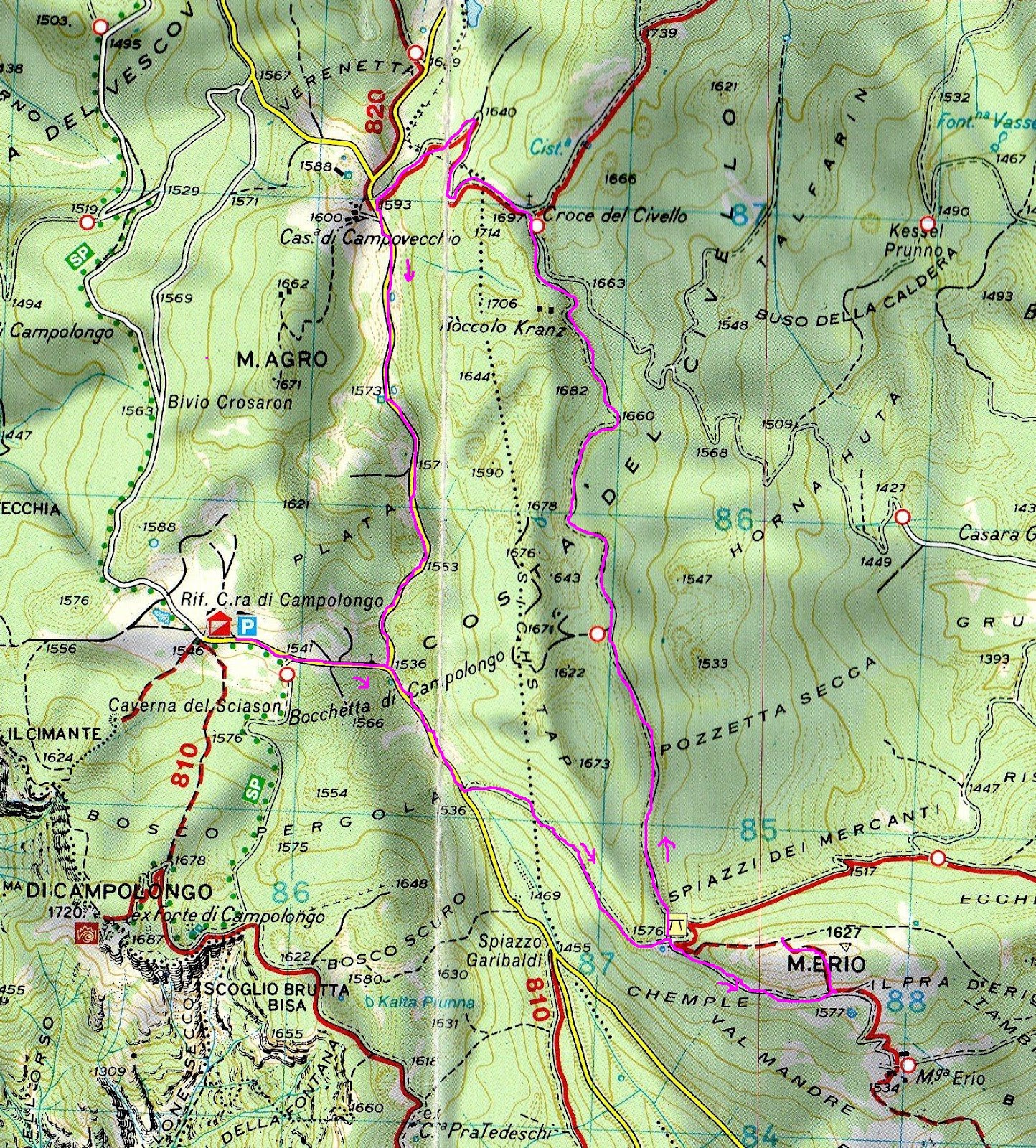
Hi there. The tag Same consideration for It often happens that, when in the mountains a place cannot be clearly delimited, standard maps typically draw the text outlining the covered region. Check for instance this map that I have just found in Intenet: MAP SAMPLE You can see that there are places, named with capital letters in this case, where the text itself shapes the related region. This is very typical for mountain areas and legacy topographic maps use to draw these regions in such ways. Examples in that map: PLATA, COSTA DEL CIVELLO, HORNA HUTA, POZZETTA SECCA, SPIAZZI DEI MERCANTI, CHEMPLE, BOSCO SCURO, BOSCO PERGOLA, VERENETTA, etc. These labels represent named sectors of mountain, without specific boundaries; they do not mark ridges, aretes, valleys, so we cannot use these already existing tags to name them. Sometimes they are sub-ridges, sometimes are partial woods (but the zone can be part of a wood and sometimes includes pastures); often (or maybe usually) they are uplands (which do not have a tag in OSM currently). From one side, marking such areas with polylines can lead to inappropriate tagging as the boundaries are not well definable; conversely, they do not deserve just a point, as they may represent an extended area, clearly shaped (often the original shape can be found in historic maps too, e.g., available in municipal archives. And in general, even through a research, a clear boundary cannot be found). In my point of view, the most appropriate tagging to represent their shape would be using OSM ways. Maybe a hypothetic They might also be considered Consider also that their representation as a line (way) can be correctly rendered by Mapnik (after appropriate configuration of openstreetmap-carto); Mapnik can render them similarly to conventional maps (like the one I linked above). Before initiating a proposal process, I would appreciate some advise here, thanks. This question is marked "community wiki". asked 09 Jun '16, 00:11 Ircama |
One Answer:
No really a question here, except of some kind of RFC, right? We have a OSM-based map rendering which shows mountain region labels in the bend style: https://wiki.openstreetmap.org/wiki/File:Maxbe-stubaier-beschriftung_en.png . I guess it only works for areas, though. However, is it really that hard to guess an area instead of a line only? I do not think so. You could use the free SRTM height data to help your guess (in case of mountains). Knowing the width of a feature is really much more information than just a line. (guesses should be indicated by a answered 09 Jun '16, 06:42 aseerel4c26 ♦ edited 09 Jun '16, 06:42
Thanks very much for pointing out this, I did not find it myself. Anyway, you are referencing While DEM can be of help for mountain areas, it might not of help at all for local names attributed to small areas within a single mountain. As mentioned before, in my point of view, the only method to tag them is using multi-point lines (way), by dragging the appropriate curve of these mountain features, where each node of the line should be placed with reference to the most common attribution to the referenced name (e.g., basing decision on local knowledge, on old and authoritative documents e.g. found in local municipalities, on governative maps with right to be used in OSM, etc.). With reference to the proposed RFQ related to the rendering of mountain areas, I think that it should involve a Mapnik upgrade. BYW, the RFQ does not mention zoom levels (min and max zooms to be rendered for mountain ranges), whether the label shall overlap, usage of capital letter, hierarchy of visualization. Coming back to features like uplands, in summary I do not think that My request would be to get some opinions on this here, before submitting an RFQ. (09 Jun '16, 08:15) Ircama |
You may know the area's name from local knowledge which you could use you may know boundaries although unless they have a fence,a tree line, a ridge, or stream it is hard to fix. Be wary, do not copy them from copyrighted maps.
In the linked example of map it is really hard, if not even improper, to imagine polygon boundaries for the features represented there in capital letters.
In my point of view, the only method to tag them is using multi-point lines (way).
BTW, I did not link a map in Internet with the goal to copy tags to OSM, but just to show how these features should be rendered.
FWIW, this isn't really the right site for getting opinions - it's meant for questions that have a definite answer. You might try the OSM mailing lists, particularly the tagging list. https://lists.openstreetmap.org/listinfo
New thread on tagging list:
https://lists.openstreetmap.org/pipermail/tagging/2016-June/thread.html#29321