NOTICE: help.openstreetmap.org is no longer in use from 1st March 2024. Please use the OpenStreetMap Community Forum

Hello !

I have a gpx file with tracks of 4 days. The tracks cover an area of 20 km2 approx. There are several roads, that have been covered several times during the trip. So you can see 4 different tracks on the same road (not exactly the same). Is it possible to convert the gpx to a Openstreetmap by eliminating all these multiple tracks automatically ?

asked 29 Apr '16, 18:01

Brentener%20Luc's gravatar image

Brentener Luc
11112
accept rate: 0%

edited 30 Apr '16, 09:20

aseerel4c26's gravatar image

aseerel4c26 ♦
32.6k18248554


So far I found only two ways to calculate an average of several GPX files with often questionable results and quite cumbersome to set up.
In case you want to read about it, have a look at my diary entries about
osm-makeroads,
average tracks and my
second thoughts on average tracks

permanent link

answered 29 May '16, 18:37

malenki's gravatar image

malenki
4.7k24683
accept rate: 6%

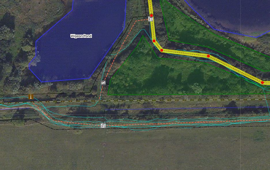
If you have traces of an area that is unmapped or an area that appears to be incorrect the best action is to upload them. The traces can then be viewed with one of the editors such as Id, JOSM or Potlatch2 and then the roads ( in your case) or tracks, paths or even rivers ( if recorded by boat) can be drawn in, and names and other tags can be added. THE automatic method is not a good idea as you will have noticed there will be some bits of trace that are incorrect. Traces are also needed when checking Bing alignment. This JPEG show the Potlatch2 editor with several cyan traces visible: screenshot of Potlatch 2

permanent link

answered 29 Apr '16, 20:33

andy%20mackey's gravatar image

andy mackey
13.2k87143285
accept rate: 4%

edited 30 Apr '16, 09:15

aseerel4c26's gravatar image

aseerel4c26 ♦
32.6k18248554

If using JOSM you need not upload your GPX tracks to use them as a guide for tracing. Don't know about Potlatch2 as I don't use it.

(29 Apr '16, 23:38) n76
1

Using multiple traces to align Bing and to average a road or path works best.(in my opinion). We can only do this if we have multiple traces and or others upload their traces as public, so we can all use them to get better results.

(27 May '16, 07:16) andy mackey

It is possible to automatically convert the tracks to a OSM way, but not advisable, because manual judgement generates better results here.

This description is for JOSM, but it works quite similar for other editors like P2 or iD.

  1. Just open all the tracks in JOSM
  2. Download currently exiting OSM data in the area you want to edit
  3. optionally: open the OSM gpx layer in the background or download other people's tracks with the gpx download function in JOSM
  4. optionally: open other position sources as layers: e.g. bing imagery or strava's gps tracks (included in the JOSM default list). Mind that aerial imagery could be shifted a bit from the true positions ("alignment" may need to be corrected). You may want to use the transparency and on/off feature of the single layers.
  5. manually look for a good average of your tracks (and optionally the other position sources). With manual inspection you see obvious gps errors like spikes to the side where the way is straight on bing and ignore them. See https://wiki.openstreetmap.org/wiki/Good_practice#Average_out_GPS-traces .
  6. manually draw the way at the average position. Draw a straight way with no nodes in-between, where there just is a straight way in reality.
  7. Do not forget to add tags to the new way.
  8. optionally: upload your gpx tracks on the OSM homepage to enable other people to see them, too (in case they want to review the way's position).
permanent link

answered 30 Apr '16, 09:15

aseerel4c26's gravatar image

aseerel4c26 ♦
32.6k18248554
accept rate: 18%

edited 30 Apr '16, 18:09

Your answer
toggle preview

Follow this question

By Email:

Once you sign in you will be able to subscribe for any updates here

By RSS:

Answers

Answers and Comments

Markdown Basics

  • *italic* or _italic_
  • **bold** or __bold__
  • link:[text](http://url.com/ "title")
  • image?![alt text](/path/img.jpg "title")
  • numbered list: 1. Foo 2. Bar
  • to add a line break simply add two spaces to where you would like the new line to be.
  • basic HTML tags are also supported

Question tags:

×622
×352
×255
×68

question asked: 29 Apr '16, 18:01

question was seen: 5,899 times

last updated: 29 May '16, 18:37

NOTICE: help.openstreetmap.org is no longer in use from 1st March 2024. Please use the OpenStreetMap Community Forum