When adding paths (and adjusting existing paths) deep inside a forest, I need to put the path points at their exact coordinates, but no coordinates are shown while moving the cursor around inside the editing window. (I realize that a recorded path from the GPS could be used, though memory is crowded, so I only record the end points and curve points.) How can I switch on "show coordinates" in the iD-editor window? This problem might very well explain why several forest paths are "off location". asked 12 Oct '15, 09:04 Geoknold |
5 Answers:
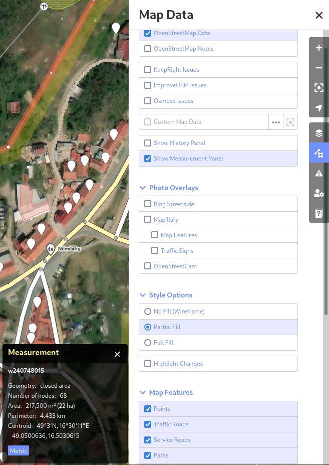
Now, this is possible by selecting "Map Data" in the right panel, then "Show Measurement Panel". This will show black box on the bottom right, with the information about selected element (area, path, point) with exact coordinates of the point, area size, perimeter, centroid and more useful information.
answered 06 Jan '22, 09:23 Jakuje |
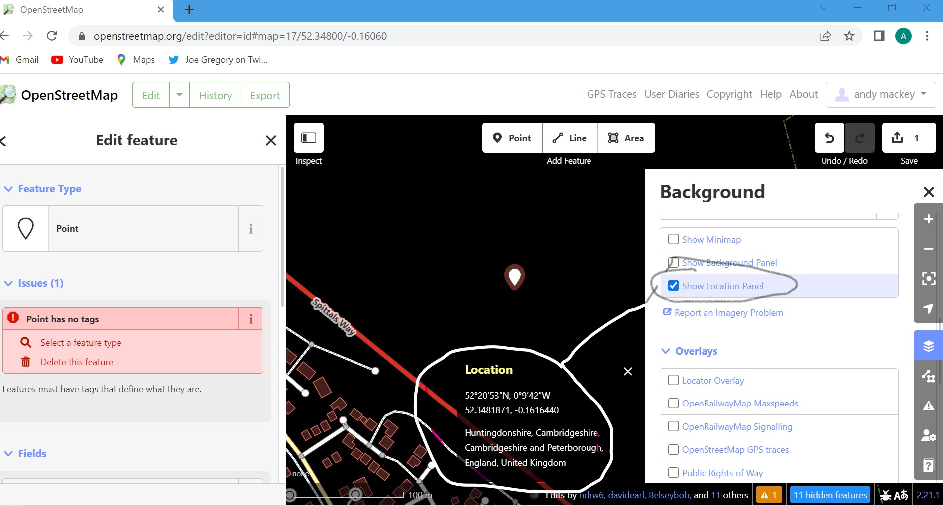
I have just discovered one of the iD features I was not aware of previously, It's not my usual editor. Select Background scroll down and tic "show location panel". I hope the JPEG will show how to get Co-ordinates Lat,Lon on screen while editing.
answered 17 Jul '22, 10:29 andy mackey edited 18 Jul '22, 06:33 |
answered 12 Oct '15, 11:37 andy mackey edited 12 Oct '15, 11:42 Thank your very much for your reply. The Extrex 30 (with GPS + Glonass) provides about 5m precision (often better when stabilizing after 1 minute or averaging), but sadly memory is small and full of geocaches etc., so recording tracks causes many waypoints to be lost due to memory overflow. Therefore, I simply record only the necessary points and wish to click the cursor at those points - nowhere else. Many forest paths seem to have been entered by transferring a path from GPS into OSM and therefore "cutting corners". By MTB'ing at 30 km/h such paths are quite inaccurate and need to adjustment. I also tried Potlatch, and can't find how to show cursor coordinates there either. Is that possible, and how? Kind regards from Copenhagen (12 Oct '15, 13:12) Geoknold Set up of your garmin:- Clear the track log just before you start the survey and put it on record a point every second. you should be able to do 10000 of them. In potlatch2 top far right of screen options, click on that then tick box for show lat lon. (12 Oct '15, 14:03) andy mackey If you connect your etrex30 to a pc you can see how much free memory it has of the 1.7gb. If it is short of space move some stuff like geo caches to the pc along with old traces or waypoints. I think that data can also be kept and viewed in Garmin Basecamp. Basecamp will display an OSM map if you do an osm on garmin download. (12 Oct '15, 14:34) andy mackey Wow. I'll call you God... :-) 1. Potlash2 -> options etc...: There it is! 2-3. Saving path on microsd: Still trying, so far no dice, but will look more into the menu maze ;-) Thanks and bye. (12 Oct '15, 14:43) Geoknold Geoknold How to see cursor Co-ords in Potlatch, options top right and tic box show co-ords (24 Jul '22, 18:57) andy mackey |
 Welcome to the help site. I don't know of a way to display cursor co-ords with iD. (It is easy JOSM and Potlatch2 ). I am wondering how you are getting exact co-ords in, or out of forests. To get the best accuracy I upoload all my traces as public to openstreetmap. When editing I display ALL available traces. I average them to check and adjust the Bing and draw paths and roads. One trace can't be relied upon but several recorded over serveral days is about as exact as most of us can get. Maybe you have professional survaying kit which may give exact co-ords, I use ordinary consumer kit. for info i use or have used Garmins etrex, Vista HCX Oregon 450 and nuvi 1310T, a Motorola defy and Tesco hudl all do record good usable traces. Hope this is of some help.
Thank you a lot - this is what i search for. how to show gps coordinates :)) Now it is simple to make some points of interest in my forest. It would be nice if there is an easy way to say - This Point on this GPS coordinates . Now i slowly move my mouse over the screen to hit it .. But better than don`t know where the exactly point is that i want to save in the map. Naja um es auf Deutsch zu sagen, das ist genau die Antwort die ich suchte.. Vielen Dank dafür . So ist es viel einfacher einen Punkt in der Mappe zu plazieren als ohne. Viel schöner wäre es jedoch wenn man dies peer Eingabe machen könnte. So bewege ich nun ganz langsamm die Maus über den Schirm damit ich den Punkt auch treffe :) answered 11 Jul '22, 18:55 Joe_West edited 11 Jul '22, 19:00 |
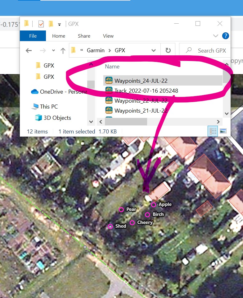
If you have some waypoints (GPX) stored on your PC or in the connected GPS. Just open iD editor then drag the waypoint(s) into the iD window. It is that simple. When I created some (as a test) I renamed them to meaningful names on my Garmin Oregon 650 and I found the name appears in the iD editor window. The group of waypoints were in a folder (named the date of the day date) and they all appear on dragging and dropping the folder into the window. For best accuracy use the averaging feature which should maximise accuracy.
answered 20 Jul '22, 06:53 andy mackey edited 24 Jul '22, 18:35 |
How do YOU get exact co-ords?
Reading this, suggests that you cannot set the 30 to save directly to microSd, unlike the old etrex,vista and the nuvi garmins. see http://www.rambler-info.org.uk/gps/howto/ht_rec_etrex10.htm When you say that you can't record a long trace you may have been fooled by auto archiving. So look in archive folder they may be there. To lessen the corner cut effect that most of us have seen in traces try:- setup/tracks/record method/ distance/000
also set auto archiving to when full and clear track just before the survey. see if that works for you.
You're saying "memory is crowded" on your etrex30 - what exactly do you mean by that?
I found some reports about a firmware bug in the etrex20/30: http://www.geocaching-ms.de/2012/05/garmin-etrex-30-speicher-voll-problem-geloest/ They quote a changelog message for a firmware update published in 2012: "Fixed issue that was causing some devices to display a ‚memory full‘ message followed by bad device behavior." Maybe updating your device firmware would solve your problem?
In a "typical" setup with a 4GB microSD card with your OSM maps, most of the internal memory could be free and you could keep 1-point-per-second tracklogs for several months on the device without filling it. Mapping is much easier and more accurate when you have logs like that, and you don't have to stop to save a waypoint at every turn (like it seems you're doing now).