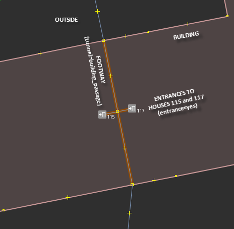
I am trying to correctly tag the following location: It's a block of apartments with a passage through the building. The block of flats is divided into several units, each with its own house number. The entrances to two house numbers (115 and 117, in this case) are located in the passage. The passage through the building is easy - I would like to know how I should place the nodes for the entrances. Technically they are both on the path through the building - but then I would be placing them on top of each other, which doesn't seem to make sense (example: way 339290816). What I've done is I've added a "phantom" section of
Is this correct? In case someone wants to look it up in the database, it's way 282416438. asked 09 Oct '15, 12:15 Lightsider edited 22 Oct '15, 21:20 aseerel4c26 ♦ |
.jpg)
One Answer:
I would change the service road to a footpath, unless cars are allowed. The short links should also be footpaths like the ones to the other entrances which I think is the best solution. If part of sevice road does allow cars and delivery vans then that section should stay as they are, but foot only section should be mapped as footpath. I had hoped that someone familiar with Hamberg may have offered advice by now. They now have the chance to vote up or down. Happy mapping answered 09 Oct '15, 23:31 andy mackey edited 13 Oct '15, 09:56 Thanks! Emergency vehicles and the occasional delivery truck (although I haven't confirmed the latter yet) are allowed, so I'll leave it as a service road. (13 Oct '15, 07:25) Lightsider 1 @Lightsider: I'd tend to map the main usage of this way, and that clearly is a footway rather than a service road. Many broader footpaths can be used by vehicles, but I think we should be mapping the primary role. If width is specifically designed to allow emergency access then I think you can tag this explicitly whilst still retaining the footway tag. (13 Oct '15, 12:19) SK53 ♦ 2 In my opinion, the small connections to the actual entrances don't exist as such in reality and should therefore not be mapped. Routers will still be able to use the data if you omit them. If you do want an explicit connection between the way and the entrances, it would be better to use better use an area:highway=* area in addition to the way. (22 Oct '15, 12:45) Tordanik |
I assume motor traffic cannot use this road, I don't think it is a service road, more like a track or footpath. but how are these wide paved paths normally mapped in your area do what they normally do in your town/country.
I tried out osrm router for car and it seems to use this sevice road.. is that correct
Yes, the road is designed for motor vehicles, although only for emergency services and the occasional delivery truck (the access roads are blocked off by bollards - I have to add them to the map).