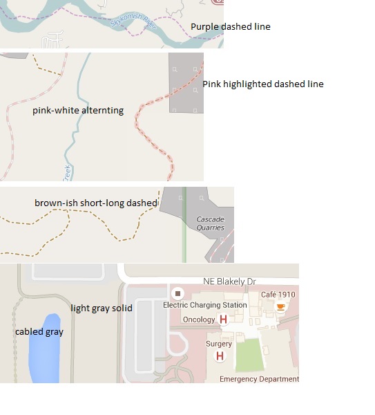
I am essentially a 'consumer' of osm maps, not doing updates myself. So, that is the orientation of this question, just want to know how to interpret the various lines i am seeing. I have found various links that purport to be osm legends (one example: https://www.openstreetmap.org/key), but the lines that i illustrate below are not defined in those legends. I use the site ridewithgps.com to access osm maps, and so as you might guess my interest is for bicycle. In order for this to be of practical use to an 'end-user' i need to know roughly what type of road or path i am going to encounter, before i can trust to map a bike ride over these marked lines. The lines i refer to (at the moment) are in this list and shown in the uploaded image. 1 purple dashed line 2 brown-ish short-long dashed line 3 white-pink filled alternating (looks a little like rr, but is not) 4 pink highlighted dashed line 5 light gray solid road-seeming line 6 light gray cabled line
Thanks much! asked 03 Jul '15, 00:08 tomconosm |
5 Answers:
There is also a wiki page describing all colours and icons. Feel free to help out to keep it up to date. answered 03 Jul '15, 06:29 escada |
If you're zoomed in far enough you can also use the "?" button and then click on a feature in the map. This will yield a list of things that are present at that location - could be just the thing you clicked on, or a couple more things in the vicinity. Hovering over items in the list will highlight them. Click on the item that represents the map feature you are interested in, and you will see the its "tags" - the attributes that describe what sort of thing it is. Not all of them will immediately make sense to you (for example, the linestyle of answered 03 Jul '15, 06:43 Frederik Ramm ♦ |
You may want to consider using a service that has dedicated bike cartography made from OpenStreetMap data, rather than the all-purpose standard OpenStreetMap style. cycle.travel is one such site (disclaimer - my site!). answered 03 Jul '15, 08:32 Richard ♦ 3 Just to clarify, picture 2 has a private road to the left and a private track to the right: http://osm.org/go/WJIquf4v (03 Jul '15, 09:23) EdLoach ♦ |
At www.openstreetmap.org pick the "i"-button from the webmap toolbar. This shows an map legend/key for the mapstyle. answered 03 Jul '15, 06:22 iii |
Omg wow thanks a lot to all for your time and assistance. I've join so many different sites for various things that interest me and being new I will post what am sure would be a somewhat stupid question and it usually gets treated as such never getting a response or many views for that matter, and usually end up discouraged never returning to it. I am pleasantly surprised and do apologize for my delay in acknowledging your efforts as I am sure you are busy as well, I will be slowly making progress here as a new member of what already seems like a very cool group of people. There are some things in my area that I want to edit as far as maps go, but it will be a slow process, I've just started a new job, well actually I think am gonna make a career of it, it will require me to take a lot of online training as well as tending to actual classroom training and I intend to go thru it full force as fast as I possibly can since I want to grow and help the company grow as much as I can. Once again thank you guys very much and hope to be back very soon. Ps am sure that this is not the proper place to respond and acknowledge you guys but I had to somewhere. Thank you Alfredo, answered 10 Aug '15, 10:07 soahcmai71 There's a description of the ways that osm people communicate with each other over at https://wiki.openstreetmap.org/wiki/Contact_channels . What you've said above would be the perfect fit for a diary entry, I'd say. (10 Aug '15, 10:16) SomeoneElse ♦ |
The bottom image looks like Google Maps, not OpenStreetMap.
That last image is from Google, not OpenStreetMap