On the cycle map there are lines of different color & width, sometimes with numbers. What's the difference between red, blue, light blue, grey? When I pull up the map key, it's empty. asked 08 Apr '11, 01:55 crams edited 08 Apr '11, 01:56 |
5 Answers:
This page has a copy of the key: http://www.gravitystorm.co.uk/shine/cycle-info/ (It would be handy if the main OSM site included the key for the cycle map in the same way that it does for "Mapnik".) answered 08 Apr '11, 02:26 Ebenezer |
In addition to http://www.gravitystorm.co.uk/shine/cycle-info/ AFAIK: A dashed blue line is a 'cycleway' (either a highway=cycleway or sometimes other highways marked with bicycle=yes) A dashed yellow line is a byway. NB This key is depreciated. A dashed green line is a bridleway. You should be allowed to cycle on these. A dashed wide dark brown line is highway=track. You can physically cycle down it (more probably on a mountain bike than a road bike) - it could be a bridleway or some form of byway; or you may not necessary have a legal right to do so (i.e. it could be private). A dashed thin browny/red (not really sure what colour this is!) line is a footway or path. You probably can't cycle on these, but sometimes a path may in fact be a cycleable 'single-track'. With the bridleway status denoted in the designation status, or a bicycle=yes tag. Various access rights may be given by either access and/or designation keys on highways: https://wiki.openstreetmap.org/wiki/Key:access https://wiki.openstreetmap.org/wiki/Key:designation I don't think Cycle Map supports designation as it's primarily a UK thing... For some parts of the UK one attempt to show these is: http://www.free-map.org.uk/0.6/about.html answered 14 Oct '12, 21:40 robbieonsea |
I too would love to know the meaning especially of some of the path colours. The link above takes you to a wholly inadequate map key. I've been to https://wiki.openstreetmap.org/wiki/Map_Features and still can't find the answers. My main query is on the cycle map I've figured out that a dashed brown line is a footpath but paths for cycles seem to appear on the map sometimes as dashed blue lines and sometimes as dashed green lines. What does the difference in colour mean? answered 14 Oct '12, 15:24 Talkingdrum |
I filed a ticket about this about 3 weeks ago https://trac.openstreetmap.org/ticket/4590 Also i happen to bump into Andy Allan at State of the Map US last night and i mentioned it to him. answered 16 Oct '12, 03:32 OpenBrian Notice the Transport Map and MapQuest versions also lack a key. I'd raise bugs, but I find the trac system almost too infuriating to use. [Now done: https://trac.openstreetmap.org/ticket/463 + https://trac.openstreetmap.org/ticket/4631 ] However I was quite impressed that the Mapnik key is aligned to the zoom level. (16 Oct '12, 22:00) robbieonsea |
This might be what you are looking for: https://www.opencyclemap.org/docs/ Of which the following image is a selection: answered 04 Jul '22, 17:49 Nima Nomad edited 04 Jul '22, 17:50 |
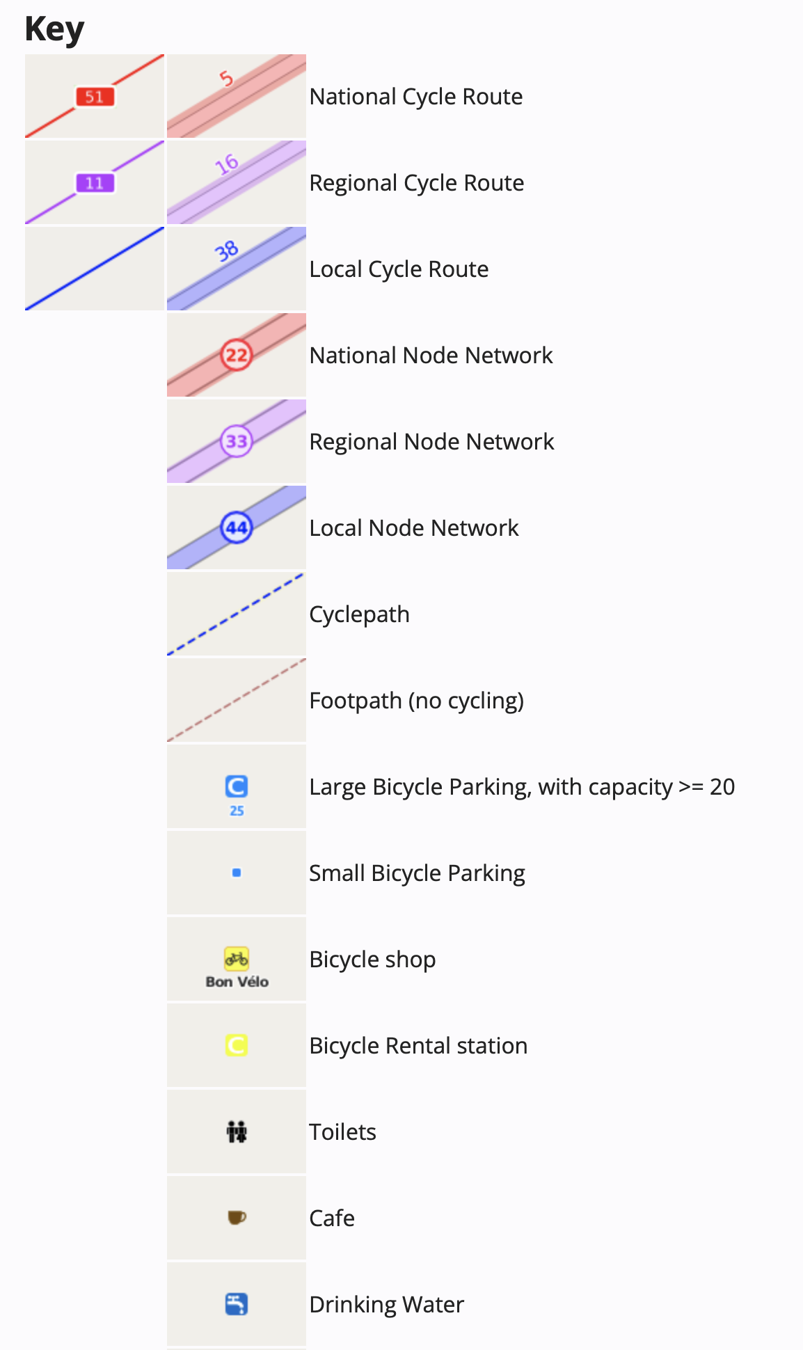
Thank you so much for that, it makes things much clearer.