Hi, I'm a new mapper so please bear with me. I've noticed that OSMAnd avoids using a well established cross road and instead routes you in a bizarre and very inefficient way, avoiding one street. I suspect this is a map data issue vs a navigation issue (navigation algorithm error.) I further suspect there is a problem at either (or both) ends of the cross street that is missed, where it intersects with the more major roads on each end. It seems either the roads are not fully "connected" (bridge type error where none exists? Altitude issue? Somehow a false turn restriction? etc.) I look at one node with the default browser editor but nothing really wrong jumps out at me in the attached gazetteer data. Is there a basic intersection FAQ or diagnosing navigation error step-by-step type procedure? Certainly not a cartographer but would love to learn how to fix things like this. Rick asked 09 Feb '15, 15:48 rjl edited 09 Feb '15, 16:58 aseerel4c26 ♦ |
2 Answers:
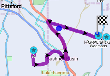
I looked at that intersection and did not see anything amiss: No turn restrictions exist there, the cross street is connected to the main road, etc. Maxspeed is missing on the primary highway which might make some difference in routing depending on how different the OsmAnd default is from the actual speed. What is the route you expect? What is the route that OsmAnd gives? What is the other end of the problem area? answered 09 Feb '15, 18:16 n76 the other waypoint of optimal route would be https://www.openstreetmap.org/node/212771263 Perhaps this is where the break is?. Below is the OSMand route from "A" to supermarket -- very convoluted and sub-optimal to say the least. This error may have been recently fixed? Still, would love to know what caused it. Am interested in the more frequent types of errors encountered in OSM, how to "diagnose", how to fix, etc. Rick
(09 Feb '15, 19:02) rjl 1 Could you please provide a Graphhopper/OSRM link of the pictured route? (09 Feb '15, 21:03) Jojo4u 2 I am guessing it is something like this: http://map.project-osrm.org/?hl=en&loc=43.069504,-77.444405&loc=43.057652,-77.502838&z=14¢er=43.064279,-77.490864&alt=0&df=1&re=0&ly=763558683 Which would imply a problem with OsmAnd rather than with the OSM map data. (09 Feb '15, 21:19) n76 … or a recent fix of our data (OSRM is usually not older than a day, IIRC), or different route preference/avoid settings in OsmAnd. (09 Feb '15, 21:29) aseerel4c26 ♦ STF - you have nailed down the absolute correct routing at http://map.project-osrm.org/?hl=en&loc=43.069504,-77.444405&loc=43.057652,-77.502838&z=14¢er=43.064279,-77.490864&alt=0&df=1&re=0&ly=763558683 In OSMand I'm showing the "green" version of the US: New York map, Edition: 2/3/2015. Using OSMand the navigation is off. (09 Feb '15, 22:09) rjl 1 aseerel4c26, The last edit I see on that route was in January so a February map ought to have the current data. Also, OsmAnd has been having routing issues for at least the last 6 months that come up on the forum at https://groups.google.com/forum/#!forum/osmand and are consistently down played by at least one poster who seems to be associated with the developers. I have found that one of the routing.xml fixes posted by another on that forum helped in my use of OsmAnd. So I'd be inclined to suspect an OsmAnd issue more than a OSM issue here. (09 Feb '15, 23:59) n76 showing 5 of 6 show 1 more comments |
"a basic intersection FAQ" is https://wiki.openstreetmap.org/wiki/Editing_Standards_and_Conventions#Junctions I am not aware of a "navigation error step-by-step type procedure". See my answer listing several options what could go wrong at western-sahara-border-routing. In your posted OsmAnd example I guess it just may be a (in this specific case) too big speed difference assumption (or preference for convenience/big roads) for motorways/primary roads vs. residential streets. In OSRM the route of OsmAnd is just 11 minutes (vs. 10 minutes for the OSRM default solution). Note that according to our current data the residential shortcut has a maxspeed of 35 (no unit, so it is 35 km/h by default = 21 mph). The primary has a maxspeed of 45 mph and the motorway 65 mph (both just spot checks). Just a guess: is that residential speed limit wrong? Should it, at least, be mph instead of km/h? answered 09 Feb '15, 21:26 aseerel4c26 ♦ edited 10 Feb '15, 02:58 Thanks for all the ideas and help. I guess 80% chance OSMand is navigating for speed vs. navigating for distance (a check box I had set) so it looks like a strong chance OSM data is fine. OSMand may need to revisit the "speed route" algorithm(s) to be sure the shortest route isn't indeed the quickest. A diagnostic checklist / troubleshooter for suspected map errors / omissions when navigation routes are messed up might also be good. OSM data isn't perfect however. Check this out: 43.08095, -77.49453 That's a huge Post Office that has been there a while. How could they miss that? (11 Feb '15, 22:00) rjl 1 … linkified: 43.08095, -77.49453. @rjl: Well, OSM is you. Please help us if you have a bit time and willingness. OSM is made only by volunteers. If you do not yet want to edit yourself (although it is not hard to start), please add a note with such info from you as a local person (add something like this "There is a huge Post Office that has been there a while. I know this place in reality."). (11 Feb '15, 22:39) aseerel4c26 ♦ 1 @rjl re. post offices, there are at least 6000 post offices which no longer exist imported from GNIS, just like the (historical) school just above the posted location. We are very short of folk who fix these obvious issues with POIs in the US (11 Feb '15, 23:02) SK53 ♦ |
Totally appreciate all the comments and info, and giving some serious thought to why is OSM U.S. data in it's current state, and why is getting public and private volunteers apparently such a challenge here?
[mod: six questions/discussion removed for clear arragement and converted to "comment"]
Please create separate questions. This is not a forum and in fact you just posted an answer consisting of several questions. This site doesn't work that way.
General questions are probably better placed on the relevant mailing lists, and in particular talk-us: https://lists.openstreetmap.org/listinfo/talk-us
I would passingly observe that the main reason European OSM data is good (q3) is that it was and is a grassroots volunteer effort, and to have yet more automated imports in the US (q4) would simply be repeating the mistakes that have left the US map so far behind the European one.
Thanks Richard, good to know. Moved to Forum. http://forum.openstreetmap.org/viewtopic.php?id=30120 and http://forum.openstreetmap.org/viewtopic.php?id=30121