I currently have a Garmin Legend HCx which is a great device that I would recommend to anyone: fast, flexible, affordable and you can load OSM maps onto it. I use it to record tracks (some of which I upload). One thing that bugs me is that it does not store the horizontal accuracy values in the GPX output. The GPX specification allows for it, the device displays an accuracy value (presumably calculated from the HDOP it receives), but it's not saved in the GPX. I think this information is important to have both for processing of individual tracks, as well as for aggregated analysis (where are the black spots in the city?). My questions are:
I am aware of the extensive list over at the wiki, but that does not seem to contain much definitive info on the DOP support specific to GPX export. asked 24 Mar '11, 13:07 mvexel edited 25 Mar '11, 08:13 |
4 Answers:
Well, this German page (English) says you can't, at least not directly, but suggests that it might be available in NMEA output. However this page suggests that NMEA output isn't available on "x" series Garmin GPXes. Therefore the answer to the first part of your question seems to be "probably not", but if there is I'm sure that there's a lot of people elsewhere on the Internet who would also like to know the answer. answered 25 Mar '11, 09:27 SomeoneElse ♦ You can get NMEA from x-series, see https://wiki.openstreetmap.org/wiki/USB_Garmin_on_GNU/Linux. However, it dosen't look like this data contain any accuracy data. (20 Jun '11, 06:54) Kagee |
Related to the second question, if you have a mobile phone with GPS capabilities that supports J2ME you may be able to find (or write) some software that outputs horizontal accuracy data in a GPX. For example, in Java on a Blackberry you can obtain a horizontal accuracy value (and FWIW NMEA strings are also available). That's a native Java call rather than a RIM API one so the code should be valid on other devices too. Exactly what you get out rather depends on how your mobile phone provider has implemented it of course, and the quality of mobile phone GPS implementations can vary. Some are excellent, some less so. answered 16 Jun '11, 19:08 SomeoneElse ♦ |
I now record and upload tracks using OSMTrack on my iPhone 4. It doesn't record the HDOP in the GPX file (so may not help in your case), but it does allow you to set an "Accuracy Filter" so that only points with an accuracy of 20m or less are recorded. It also continually shows you the current GPS accuracy, which is presumably based on HDOP information.
Typically the accuracy is reported as 5-10m for a good fix. answered 21 Jun '11, 10:25 GrahamS |
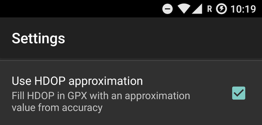
OSMTracker for Android can record HDOP information. Just enable "Use HDOP approximation" in the Settings:
It works on any Android device. Free and open source. answered 16 Sep '17, 04:33 Nicolas Raoul |
I can't help answer your question, but have added to the wiki page you mentioned that the Locosys GT-31 supports HDOP and PDOP (according to the manual - the .gpx file I looked at locally definitely has an HDOP figure in - I may be losing the PDOP logging to the internal SBN binary format and converting later rather than raw NMEA)