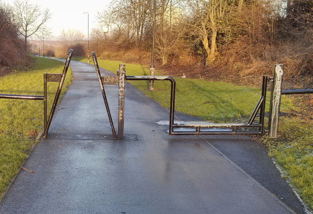
There are quite a lot of this type of path barrier near me - see attached picture. They allow passage for pedestrians, cycles, prams, wheelchairs and horses but are an impediment to motorcycles and larger motor vehicles (unless you have a very narrow and high 4x4!). Does anyone know if they have a specific name? (I'm just curious about that.) But, more importantly, how should I map/tag them? (I've been adding them as cycle barrier nodes so far but I know that isn't correct.)
asked 02 Jan '15, 13:43 Garry Patchett edited 08 Jan '15, 01:37 aseerel4c26 ♦ |
4 Answers:
I'd artificially split the path so that parallel paths go through each barrier, and I'd map the right-hand one as a horse_stile. It looks like it's combined with a gate, but I personally wouldn't map the "gate-ness" of it unless the gate could be opened to allow wide motor vehicle access. For the left-hand part I'm not sure that This answer is marked "community wiki". answered 02 Jan '15, 14:25 SomeoneElse ♦ edited 02 Jan '15, 14:33 1 That sounds like a neat solution to me, thanks. The right-hand side can be opened to allow vehicles through but only by people with a key - e.g. the local council - so it's not a "public gate" as such. I've seen people using the path on motorcycles - even though they're not supposed to - so it's possible to get them past but I don't know if they squeeze them through the left-hand side - as most bicyclists do - or carry them over the right-hand side. (02 Jan '15, 15:08) Garry Patchett cycle_barrier should be OK for the left one - certainly it is impossible to pass it safely on a bicycle. (04 Jan '15, 16:12) Mateusz Koni... 2 @Mateusz Konieczny: Looks more like https://wiki.openstreetmap.org/wiki/Tag:barrier%3Dmotorcycle_barrier than https://wiki.openstreetmap.org/wiki/Tag:barrier%3Dcycle_barrier to me... (06 Jan '15, 14:41) Piskvor @Piskvor: I agree that the left-hand side looks more like a motorcycle barrier than a cycle barrier (as in the wiki photos). @Mateusz Konieczny: Getting through on the left-hand side on a bicycle is relatively easy. You need to stop, turn the handlebars to the side, and bump/carry the front wheel through. It's restrictive but not impassible. (Some narrow cycles don't need to stop, just slow down.) I think the general intention was to impede all non-authorised motorised vehicles (except motorised wheelchairs etc.). I've updated the map with deference to the advice given. Thanks to all. (07 Jan '15, 10:26) Garry Patchett I believe this is (fairly rarely) tagged as cycle_barrier=squeeze, see taginfo: http://taginfo.openstreetmap.org/keys/cycle_barrier. (07 Jan '15, 12:40) SK53 ♦ @SK53, Until you gave me the link I didn't know anything about the TagInfo sub-site and it looks very interesting. Thanks for the pointer; I'm sure it will come in very handy. As for tagging the barrier with "cycle_barrier=squeeze", I think I'll wait a while before making a change. As you say it's not exactly popular, so I don't want to propagate further something that may not be right. Of course, I can always change it later. (08 Jan '15, 10:02) Garry Patchett 1 It might be helpful to search http://taginfo.openstreetmap.org.uk/ for values "squeeze" and "squeezer" to see the numbers used and geographic spread (the latter is quite widely used on stiles). (08 Jan '15, 10:08) SomeoneElse ♦ Thanks @SomeoneElse. I've just had a quick look - and used Overpass Turbo for the first time (it looks very useful) - and there's even more of interest there than I first realised. "barrier=shoulder_squeeze" is an interesting option that looks relevant (I just wish I could see a photo of one of the nodes of interest). I'm still learning so I'll not make any changes just yet (I'd have to make an en-masse change so they're all the same), but there's a lot for me to look at and try to understand (fingers crossed). Cheers. (08 Jan '15, 12:47) Garry Patchett showing 5 of 8 show 3 more comments |
Hi Garry, Please also check that you add restrictions on the path (which should be highway=footway) with bicycle=no motorcycle=no and horse=yes. As the horse may well use the soft verge you could run a parallel way with the tag highway=bridleway. answered 07 Jan '15, 21:20 RAytoun 1 The only slight caveat to that would be if the barrier at the left wasn't to stop cyclists altogether but just to slow them down (other signage should make that clear). (08 Jan '15, 09:14) SomeoneElse ♦ Hi @RAytoun. The path is currently mapped as a bridle path but it is also part of a major cross-country walking route, that is also used as a cycle route (in parts). It's very confusing as to how to best tag it but I'm still learning so I'll look at what you've said and do what I can. As for horses using the soft verge, after seeing the sort of stuff that's lying around on the verge, I think the riders would prefer to use the asphalt path for horse-safety reasons. But your suggestion is something I'll keep in mind for other paths. (08 Jan '15, 10:08) Garry Patchett @SomeoneElse, I think the barrier is meant to make cyclists actually come to a stop and lift their bikes over the right-hand side but people will always try and get round restrictions when they can. You just can't fight human nature. Well, you can, but it tends to fight back sneakier! (08 Jan '15, 10:09) Garry Patchett |
Hi Gary, how about asking the operator (community) of the parkways 'whats the use of it' ? answered 07 Jan '15, 12:17 Hendrikklaas I doubt the operator is familiar with the OSM tagging scheme. (08 Jan '15, 07:38) scai ♦ 1 Hi @Hendrikklaas. That's a really good suggestion but I've a feeling that I'd be endlessly passed from pillar to post without getting to someone who could give me the relevant information, or just ignored completely. The next time I'm passing one I'll try and see if there's a manufacturers' stamp/plate - making sure no-one else is looking at the "weirdo with the barrier fetish"! - and maybe take it from there. (However, I've a feeling that these things were made "in-house" by the local council, so I might not get anywhere that way.) (08 Jan '15, 10:00) Garry Patchett Signage should give access information. Then add foot yes or no, cycle yes or no and horse yes or no. I the UK Bridleways allow all three. Contact the land owner. I this case it looks like it's council property, or a nature reserve owned by a charity. Often an information sign at entrances which may yield websites or phone numbers for more information. It also looks well maintained you could ask the guys or women that are looking after it, easier to find during week days though. (27 Sep '20, 12:32) andy mackey |
Sorry I haven't worked out how to fork these discussions. Fwiw, I got in touch with Sustrans who (used to?) maintain these cycleways in coordination/in competition with the local councils through which they pass. This is what they said: the link has rotted, but you can find comparable info here. They seem to be called 'A-frames' in the Sustrans lexicon. *Hi, Thank you for your email. Please see the link below, this should provide all the information you require about barriers: https://www.sustrans.org.uk/sites/default/files/file_content_type/access_control_guide_jan_2012.pdf Also for reference, please see below a link to our position on access controls on paths. As organisation we believe accessibility for all is of upmost importance. There should be a presumption for paths to be open to all legitimate users with minimal or no access controls. If some form of access control is necessary, a single row of bollards (or other features, such as rocks or planters) leaving 1.5m gaps and with clear visibility of other users can be effective in many locations. https://www.sustrans.org.uk/our-position/access-controls-paths Many thanks NNN Digital Marketing Assistant www.sustrans.org.uk* answered 26 Sep '20, 10:34 eteb3 |
I'd like to thank all of the people who have given answers and comments so far. I really didn't expect my "silly little question" to provoke such a response and I'm very grateful to everyone that has been helping me. I've been learning a lot.
It's opened my eyes to a (slightly, in my case) "deeper" understanding of how mapping is done and the underlying complexity that is involved. I now realise that the little job I started of mapping my local area will be much more involved and take a lot more work than I first thought. But, at the same time, it's given me a greater impetus to learn more and do it properly.
So thanks again to everyone who's taken the time to reply and I'm looking forward to learning much more about all of this in the future. (Once you scratch the surface this stuff is so bloomin' interesting.)