Hi, I am trying to find a reliable GPS navigation app on my phone. I have tried many now and I have come to the conclusion that at least for a few OSM seems to be the problem. The GPS nav has big issues on dealing with large junctions, such as one near me called "handy cross". All the different GPS apps using OSM data say to "Go straight ahead" at the aforementioned junction, however being a large junction with 4 lanes, there is no "Straight ahead". If you look at the junction you can see that "Straight ahead at the roundabout" can be construed as multiple roads. Coming from the A404, heading north "straight ahead" could be any number of 3 exits. Now I would attempt to fix this myself but A. I don't know how and B. This particular junction is just one of two we encountered yesterday when testing a few different gps apps. Now is there anything that can be done, or is it just a case of the 3 GPS apps having bad navigation software? This question is marked "community wiki". asked 30 Aug '14, 04:32 crimsonknight3 edited 30 Aug '14, 12:26 aseerel4c26 ♦ |
2 Answers:
At least one part of the Handy Cross roundabout seems to be missing the junction=roundabout tag. Looking at the roundabout, it isn't a typical roundabout as there is a shortcut across the middle, so it might be the junction=roundabout tags aren't appropriate in this case, but that will affect the directions that GPS apps give, generally, as they'll treat one way trunk roads differently from roundabouts. In this case it might be worth looking at using lane tagging (lanes= and turn_lanes= ) which I believe at least OsmAnd uses giving on screen hints as to which lane you need. answered 30 Aug '14, 07:39 EdLoach ♦ |
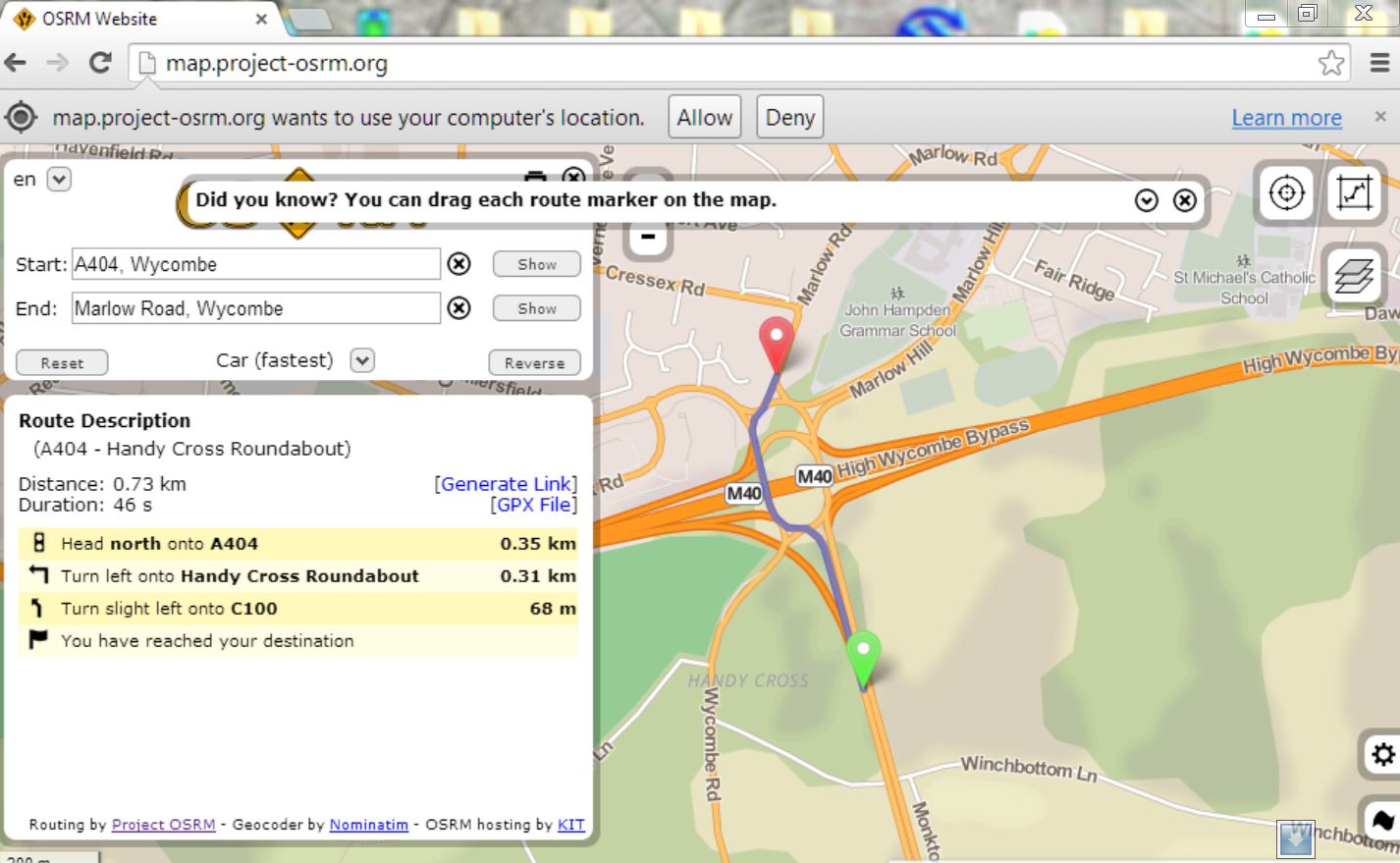
I would use OSRM routing to test OSM data before blaming OSM, if that works ok it not osm fault. Then you should contact the creators of each app with a details of the problems you found. If the OSRM test shows a wrong route it will need correcting. For someone to do that they would need local knowledge, some surveying plus good understanding or some time to learn how turn restrictions are mapped. This question may be of some help. Using OSRM, plot a a pair of start and finish points either side of the area you wish to test, then then try the reverse route or drag the points to somewhere else, It will give the routing a good test, The junction in question looks good to me.
answered 30 Aug '14, 07:57 andy mackey edited 30 Aug '14, 20:48 The problem is you say that junction looks good to you. An instruction saying slight left onto C100 is a pretty poor instruction considering it is only useful RIGHT before you exit AND to boot, you have no warning to know which lane to get into. The best way to handle this kind of junction is to say "Take third exit" etc.. Also note that the 3 gps apps I have tried on my phone using OSM have said "At the roundabout go straight" so there are conflicting instructions between OSRM and other apps. I know I am not being pedantic by thinking these instructions are too vague for a multi-lane junction (30 Aug '14, 18:40) crimsonknight3 The OSM data seems accurate. I agree that OSRM routing instructions need to be followed with map which isn't ideal. In my opinion your detailed criticisms should be directed to the creators of each individual routing app. Feedback can then give them ideas on how to improve their work. (30 Aug '14, 20:36) andy mackey 1 I have been attempting just that with the app developers but they all insist its the OSM data and not their app. Despite this I have still repeatedly said that "straight ahead" or "left" when approaching a complex junction with multiple exits at each point of a "compass" persay, is too vague. Now I don't expect them to say which lane to get into, that is down to the driver, however for complex junctions it SHOULD say which exit as a number, like almost every standalone sat nav does. I will keep adding to the OSM data, nag the app devs and will just have to grudgingly buy a standalone satnav :) (31 Aug '14, 00:21) crimsonknight3 I've noticed that some roundabouts have good lane markings which spiral out to your named road. Mapping them could be hard without Hi-def image, and I doubt normal GPS is accurate enough for lanes. still give it while and the "self steered vehicle" will do it for you, routing will have to be dead right then. (31 Aug '14, 08:57) andy mackey |
Discussing those specific problems and map in collaboration with others (as you seem to be quite new and this one is not quite easy) might work best in a chat, local forum or maybe local mailing list as this help site is meant meant for questions and answers. If you, later, ask elsewhere, please link to this question here and add a link here to the follow-up location.
For an example route with graphhopper or with OSRM I get no "straight ahead" (note that those routers do not always have ultra up-to-date data which is used for routing). Did you use other routes in your navigation examples?