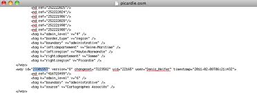
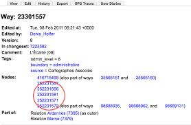
Hi, I'm using the geographic .osm subsets generated by GeoFabrik that can be downloaded here: http://download.geofabrik.de/osm/europe/france/ However, in some of them, I found some strange ways definitions (missing nodes), this sounds to me like a mistake from their side, a kind of inconsistency that occurs during the generation of those subsets. However, as I'm relatively new to OSM, maybe you can confirm that this is a mistake from their side. Here's the definition of the way 23301557 in their file: (with only one node in it) And here's the way it is defined in OSM : https://www.openstreetmap.org/browse/way/23301557 Can you confirm me that this is due an error on the geofabrik side and not something I'm missing in my use of the .osm file ? Thanks a lot. asked 15 Feb '11, 14:02 y0n3l |
 Some nodes seem to be missing.....
One Answer:
What you are seeing is the result of these extracts being created with the Osmosis option Osmosis has two other options how to deal with these situations. One is If you cannot work with this file, you will have to use the next larger extract (e.g. france.osm) and then cut out your area of interest yourself with a suitable set of parameters. answered 15 Feb '11, 14:09 Frederik Ramm ♦ edited 15 Feb '11, 14:18 Jonathan Ben... |
Thanks for your detailed answer. I would have prefer to avoid using the france.osm but if that's the only way :/ Would you know a "fast" way to get all the nodes that refer indirectly to a relation ? I "just" want ways / nodes for a predefined administrative boundary ( http://bit.ly/ifGan3 ) should I parse the france.osm "only for that" :/
Ok I think that the easiest way to do what I want is to rely on the api and ask for the members of the relation using http://api.openstreetmap.org/api/0.6/relation/7411 and so on for the ways and then the nodes..... As the api also supports multi fetch, this is a nice and fast solution.
This is not necessary. You can use http://api.openstreetmap.org/api/0.6/relation/7411/full to give you all referenced objects. However don't do any of this on a regular, automated basis - it's ok for a one-off.
Thanks a lot for the tip ! Yes I only need to do it one time for some relations.