This section has no selections to request or to download the map (no buttons): Request your map or download it directly: (Make a selection first) asked 25 Sep '13, 14:51 brucemon edited 25 Sep '13, 23:46 aseerel4c26 ♦ |
2 Answers:
The "download map" button will only be active if the particular choice has already been generated in the preceding 120 hours. If the map has not been generated, you will need to enter your email address and click the "Build my map| button. This arrangement exists as the process of generating maps is resource intensive and it is impractical to pre-generate maps for the whole planet each week. For the USA, you will only be able to request / download on state at a time. Check out the FAQ and Manual for advice on using more than one map at a time. answered 26 Sep '13, 07:01 rovingmedic |
If you mean http://garmin.openstreetmap.nl/ … you have to enable "Manual tile selecton mode" in the section above it. Then you can click single areas. (See Garmin.OpenStreetMap.nl:Manual#Manual_tile_selecton_mode Note that full country downloads (drop down moxes) are faster processed (Pre-made), some single tiles could also be already available. Downloading the whole US does not seem to work at garmin.osm.nl - that is also indicated by no "-" symbol in the drop down list. Please select a US state or use "manual tile selection". Try Dave H's maps (direct link - there is one 4000 MB map of the whole USA, see readme file there). answered 25 Sep '13, 16:33 aseerel4c26 ♦ edited 21 Oct '13, 16:31 I don't want to select manual tiles. Full country download button is not available on http://garmin.openstreetmap.nl/ (25 Sep '13, 22:42) brucemon 1 Works for me - but only if I pick a "popular" country:
as opposed to:
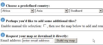
I guess your options are either to change your travel plans or wait the 6 minutes for a country map link to be emailed to you :) (25 Sep '13, 23:12) SomeoneElse ♦ The "Download Map Now" isn't on the web page. (25 Sep '13, 23:27) brucemon 1 It was for me 17 minutes ago (depending on the country you pick) - see screenshot above. Which country are you trying to download a map for? (25 Sep '13, 23:32) SomeoneElse ♦ 1 United States. I tried both IE9 and Chrome. Same result. (25 Sep '13, 23:33) brucemon 2 Which state? As the web page says, you need to make a selection first:
(25 Sep '13, 23:37) SomeoneElse ♦ 2 I downloaded the whole USA 2012-12-26. The file size is 3,598,528 KB. Works great on my Garmin Oregon 450. It was a godsend when we had to change plans in Glacier National Park. Being from Florida (thats 3,000 miles away) it was AWESOME having the entire map. That and I hit 5 other National parks in 5 other states. All on the same trip (7,100 miles total) last summer. So... what changed all I get is "Loading data, please wait"? Doesn't matter if I select UK or USA or Florida. Tried in Chrome and Firefox. (28 Sep '13, 03:21) aerod showing 5 of 7 show 2 more comments |


So I have to download each state separately? If that's true, it seems clunky.
Use the manual tile selection mode if you want to download more than one state at the same time. There may be a limit on the maximum number of tiles you can download too (?4GB file size limit). Check the FAQ on the website for more info.