I draw some coastlines, how can I add polygons that use the same nodes as the coastline. E.g. The rather complex coastline is made up of cliffs so I want to add and area with "natural=cliff" along it, but I don't want to click every node in that coastline one more time.
This is the same if I want to tag landuse=forest, and then have a joining landuse=farm. asked 26 Jan '11, 09:17 emj |
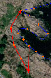 complex coastline (blue) + other area (red) that should use the blue line too
5 Answers:
JOSM now has a follow line tool similar to that of Potlatch that allows to easily create a new way along an already existing way. answered 14 Aug '11, 15:53 scai ♦ edited 14 Aug '11, 15:54 |
I found JOSM plugin contour merge it seems to do it, does it work?
This answer is marked "community wiki". answered 26 Jan '11, 09:23 emj wikified 20 Feb '11, 08:06 |
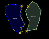 from this
 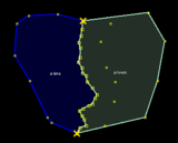 to this
In Potlach2 start by making some nodes and when you get to an existing line you wish to follow do a couple of nodes along it then press f (for follow) (see my question Potlach2 using natural boundaries for tagged areas) answered 20 Feb '11, 10:33 andy mackey edited 20 Feb '11, 16:53 gnurk |
In JOSM, you can achieve that with some tricks:
It's a little bit tricky, but I haven't found another way to properly duplicate the wanted path. answered 21 Feb '11, 12:01 NicolasDumoulin edited 21 Feb '11, 13:28 |
You shouldn't be making overlapping ways, use a multipolygons instead. Draw each boundary line once then add it as an outer way in a landuse multipolygon. answered 29 Jan '11, 22:07 Binary Alchemy emj, https://www.openstreetmap.org/browse/relation/392840 and https://www.openstreetmap.org/browse/relation/392841 may give you some hints. Also specifically read https://wiki.openstreetmap.org/wiki/Relation:multipolygon#Tagging from the link Alchemy already gave you. For example: "It is suggested to apply all tags which describe the area to the relation, and not to the ways. In many cases this may result in completely untagged ways." (BTW: The parking area nearby isn't pretty done, but the examples above still should give you the idea how to reuse already existing ways.) (31 Jan '11, 14:19) gnurk |
Very easy to use, this works great!