I would like to create a clickable map of UK ceremonial counties ( a little bit like : http://activeden.net/item/uk-interactive-map-over-130-clickable-counties/full_screen_preview/45933 ). My intent is to provide an easy way to click through to county level maps with GPS trail data (using openstreetmap), and therefore wondered if there was a way I could utilise openstreetmap to also achieve the county level mapping as well, maybe using a different tile collection? I've searched on Google but haven't found any signs of a county level tile set (ie. no roads / other stuff). I assume it's a far from trivial task to try and extract this small subset of data, and render a new tile collection? Any thoughts / advice on this would be much appreciated. Thanks, Paul asked 21 May '13, 16:29 PaulNorwich |
2 Answers:
I found a decent one at: https://wikishire.co.uk/map
Not sure exactly how it was created, but it does use OpenStreetMap. This page describes the map: https://wikishire.co.uk/wiki/Wikishire:Map but does not give any useful information on its construction. An interactive map with districts can be found here: https://mapping.dorsetforyou.gov.uk/map?version=mylocal&lyrs=50 but it seems to use Ordnance Survey data, I'm not sure if that data could be reused or not on OSM. answered 25 Dec '20, 09:12 Ciro Santilli edited 27 Dec '20, 10:13 |
First of all, do a text search about keywords like boundary or borders at the search box of this FAQ site ... there are a bunch of topics dealing with the exclusive filtering or displaying of borders taken from the OSM data. Secondly you want a feature to highlight a certain region if the mouse hovers over it, and make it clickable ... try to look at openlayers.org or leafletjs.org ... they have a lot of examples how that feature may be offered. Or have a look at download.geofabrik.de and hover over the list of countries or continents there ... each is highlighted on the map on the right screen. If this or similar is your aim, ask the team from geofabrik.de how they did it. answered 22 May '13, 16:31 stephan75 |
Strictly speaking, those are traditional (historic) counties rather than ceremonial ones, I think. Ceremonial counties are what you can see at https://en.wikipedia.org/wiki/Ceremonial_counties_of_England . This may or may not be what the question asker actually wants of course!
Some traditional counties are complete in OSM, for example Flintshire: https://www.openstreetmap.org/relation/363512 , but some are not: https://www.openstreetmap.org/relation/8743599 .
@SomeoneElse: thanks for the info!
... and what I should have said is that I think that UK ceremonial counties are in OSM. See for example https://www.openstreetmap.org/relation/77268 (ceremonial) as opposed to https://www.openstreetmap.org/relation/181040 (administrative). I suspect that some of the ceremonial ones may be broken multipolygons (Notts and Derby both were until I fixed them recently) because they're not widely rendered. You could use a similar approach to https://www.openstreetmap.org/user/SomeoneElse/diary/395232 to find issues.
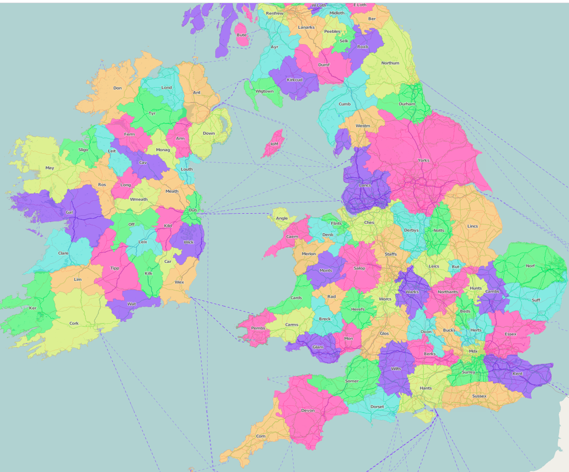
@SomeoneElse is there any way to see all counties (cerimonial/adminstrative) all at once on the map and hopefully clearly named/even better colored as in the wikishire map (but with guaranteededly open data)
There are a few different ways. For small areas https://overpass-turbo.eu/s/11PB will work. Maybe you could do something with http://umap.openstreetmap.fr/en/ , and also creating a "normal" OSM map but with only ceremonial county data in it might be an option - see https://www.openstreetmap.org/user/SomeoneElse/diary/47027 for a bit more on that. I'm sure there are lots of other ways too.