When using keepright to check for errors, I notice that there are quite a few entries of the type, "This node has tags in common with the surrounding way" in my locality. These appear to typically be schools or other amenities with both a polygon tagged as a school and a single node also tagged as a school. If the single node is removed, the school symbol is no longer displayed. Is there a way to get both the outline and the symbol rendered without having duplicate information? asked 24 Oct '12, 21:35 Mike Baggaley |
One Answer:
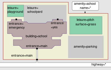
It is wrong to have both the area way and central node. If you see this, then generally the correct thing to do is delete the central node. One feature, one OSM element. I tend to draw in a large area encompassing the building or buildings, and car parks and sports pitches. The amenity=school tag goes on this encompassing area. Something like this illustration from the amenity=school docs
But you were asking about the symbols. In the "standard" OpenStreetMap map rendering, the map doesn't currently display a school symbol regardless of whether the school is mapped as a node or an area. So I guess you mean in the Potlatch editor the symbol is no longer displayed, or maybe in JOSM. They both do this actually. None of this is a problem though. You're not doing it wrong if you don't see the school symbol. answered 25 Oct '12, 02:44 Harry Wood |