I'm interested in identifying the most common mapping errors you stumble upon from other OSMers (or that you make yourself). If we could list some of the most common mistakes then we could use that information to drive improvements that may help to prevent the same mistakes being made in the future (e.g. by clarifying the wiki documentation, modifying the editor UI, writing scripts to find the mistakes etc). This is obviously a very subjective question, but hopefully some people may find the answers useful. Please try to stick to definite actual errors, rather than simple differences of opinion. This question is marked "community wiki". asked 06 Oct '10, 15:01 GrahamS |
30 Answers:
Not Mapping!The most common mistake users make, is to register for OpenStreetMap, but then fail to do any map editing at all. Strange but true! See pascal's „Nominal Members“ of OSM? blog post. Please all you people. Have a go at mapping! Make mistakes. We don't mind. answered 06 Oct '10, 17:03 Harry Wood edited 07 Oct '10, 09:47 GrahamS showing 5 of 10 show 5 more comments |
Unconnected Ways
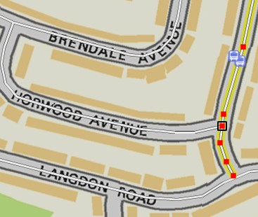
The selected way is a residential street that should clearly form a junction with the "Langdon Road" way at the bottom of the image. But as you can see, there is no black box around that point, so the original OSMer has actually missed and the result is that the way stops just before it gets to "Langdon Road". I see this mistake a lot (which is what prompted me to ask the question). It is barely noticeable when just viewing the map, but it really messes up routing through these streets and I usually find errors like these when investigating reported map bugs from skobbler answered 06 Oct '10, 15:32 GrahamS edited 06 Oct '10, 15:34 8 Indeed unconnected ways are a fairly common issue despite both potlatch and josm indicating quite well when a way is connected and when not. One tool to help find and fix these errors is the OSM inspector - routing view. ( http://tools.geofabrik.de/osmi/?view=routing&lon=-0.02490&lat=51.36767&zoom=6 ). But as with all automated tools, it also has a number of false positives / negatives, so it can't be used blindly to fix these. (06 Oct '10, 23:57) apmon @apmon: thanks, I'll try OSM Inspector. I had a play with the "keep right!" tool mentioned by @scaii and found it was very useful at finding these errors. It refers to them as "almost-junctions". (07 Oct '10, 09:51) GrahamS 7 http://keepright.ipax.at/ is almost obnoxiously efficient at finding these. (23 Feb '11, 22:21) Baloo Uriza curiously, I tried both the OSM inspector and "Keepright", and I don't find the same misses! But from experimenting around my area I cans say both detect real lacks of connections :-) Hervé (15 Apr '11, 13:38) Herve5 @Paul Johnson thanks for mentioning Keepright! I have used OSMI, MapDust, OpenStreetBugs and probably other QA tools, but Keepright is very cool and helpful. (15 Apr '11, 22:24) ponzu What's the easiest way to fix this in Potlatch? (31 May '11, 21:41) Munchabunch @Munchabunch: In this example I'd select the last node in the highlighted way, press the '-' (minus) key to delete it, then click on the Langdon Road way to connect them properly. (15 Aug '11, 09:36) GrahamS You can move the node over the way to which it should be connected, and press 'J' for join. (05 Sep '11, 11:27) Richard ♦ 2 OpenStreetMap.fr has also developed an excellent QA tool (Osmose) that covers now the world, with live updates. Compared to KeepRight, it is often much more precise, more detailed, with useful fixes proposed, at least for Europe and its dependencies on other continents (except possibly Asia), and it is fresher (better fix things sooner than later and give help to the author, to avoid other problems). But unconnected ways, and unclosed boundaries ARE detected everywhere. Additionally, this tool speaks YOUR language (KeepRight just speaks English or has poor translations). (27 Nov '12, 10:30) Verdy_p The easiest fix in JOSM is to start dragging the ending node, then presssing CTRL while dropping the node to the other way to join with it. Note how the mouse cursor changes when you're pressing CTRL while still dragging the node... pressing 'J' with the node selected sometimes moves it and connect it to the wrong nearby way. Another solution: press CTRL to create the intersection node on the way, add the other node to the selection and press 'M' to merge the nodes (but this will move the newest node to the oldest one, so a straight way would become non straight) (27 Nov '12, 10:37) Verdy_p Also, when you see unconnected roads, you may just move back the final node up to the point where there's a pedestrian crossing. Add the crossing tag, the stop marks for vehicles, Then select that node and use the line mode to terminate the way to the crossing point. Finally add turn restriction on this new final node. (27 Nov '12, 10:46) Verdy_p This kind of problems is really easy to find using JOSM validator. (03 Jul '14, 17:13) Mateusz Koni... showing 5 of 12 show 7 more comments |
Using non-descriptive changeset commentsIt's helpful to know (especially on "big" changesets) exactly what was being changed. Comments such as "Fix Tags" and "Fixed Stuff" don't really help; always try to put something in there (even if it's just referring to where the changes were made). (and in the interests of full disclosure - I can be as guilty as the next person of this "common mapping mistake") answered 07 Mar '11, 15:05 SomeoneElse ♦ 9 Yes, and it is also helpful to try to avoid "big" changesets, and make them small enough that the description is precisely referring to the actual changes made. (07 Mar '11, 15:20) dieterdreist 2 sometimes with potlatch2 I start editing and save and give a description of the edit, then go on editing and the program doesn't ask me for a new description... so my second save inherits a description that isn't necessarily correct. (05 Sep '11, 14:41) mariotomo 2 You can ask Potlatch 2 to close a changeset by pressing "c". Then the next time that you save, it'll ask you for a new changeset comment. (05 Sep '11, 14:48) SomeoneElse ♦ 2 In general I'd say this is not so much a "common mapping mistake" but more of a thing we'd like new users to "graduate" onto doing, once they're getting the hang of editing. I don't think it should be regarded as essential, or rude not to. I do always try to add a good comment. Techy people are very fastidious about this kind of thing, but it might take some new users a while to pick up the habit, and that's fine. @miriotomo yes. I make the same mistake quite a lot when dipping into Potlatch editing. I know about the 'c' button, but tend to save by mistake expecting to be asked (like in JOSM) (12 Jun '12, 16:20) Harry Wood Thanks, C is new for me, but pressing it, costs time to save it. I usually feel lucky if the question is nt displayed. Ill improve myself. (14 Aug '12, 23:17) Hendrikklaas 1 @SomeoneElse You might want to add "and creating changesets than span continents". It's exactly the same problem, as the following mappers can't see what has happened. It also completely breaks the history page of openstreetmap.org. (19 Aug '13, 16:06) Chaos99 showing 5 of 6 show 1 more comments |
Highway ClassificationA common error from newbies is the highway classification. answered 06 Oct '10, 17:31 Pieren edited 07 Oct '10, 09:47 GrahamS 1 I know this subject has been pounded into the dirt, however, the primary/secondary/tertiary and footway/cycleway/pedestrian/path distinctions seem to cause the most troubles. (23 Feb '11, 22:23) Baloo Uriza 2 In Portugal and Cyprus I have entered roads with highway=road because it is impossible to rate them on a survey. However all these have been edited to highway=unclassified. In Cyprus, even some dense residential areas do not have street names but block names (eg Sea View Gardens on one side of the road and Sunset Villas on the other) and I still have not figured out how to name the highway=residentials. I have sometimes used landuse=residential name=Sunset Villas but what about the addresses when one side of road belongs to Sunset Villas and the other to Sea View Gardens? (24 Feb '11, 06:47) dcp 2 This is not a forum. You should convert your comment to a new question ;-) (24 Feb '11, 08:44) Pieren You can see this quite often in Italy: highest highway class in urban centres (sometimes quite big ones with place=city) is tertiary or unclassified. All primaries stop before the city and restart after it. Up to some time ago even Milan had only tertiary streets inside the city, but fortunately this is slightly improving now. (27 Feb '11, 11:06) dieterdreist 1 That's a good one! I only recently started converting some of the streets that I (and others) had tagged as tertiary to unclassified. I had completely misread originally what unclassified meant. And I do live in one of those countries, for which this classification means little. I don't know if this is cheating, but when in doubt I peek at Google Maps. They only have two colors: white and yellow. I have decided that Google's yellow covers our primary, secondary and tertiary. If a road is not yellow in Google, I tend not to tag it higher than unclassified. Or is that another mistake? ;) (15 Apr '11, 00:01) ponzu |
Aerial imagery offset In my area almost all new users don’t know about aerial imagery (Bing) offset. So they start drawing new objects without offset imagery at all. Sometimes even worst, they start moving old objects. Then I have to communicate them and revert or fix their edits. And True_Offset will not really helpful, because it change to frequently in hill area. From my point of view we have to keep remind new users of any editors necessity to adjust imagery. Maybe we can keep mark in database for users who confirm that he knows about offset. answered 07 May '11, 23:20 Dmitry Teren... edited 07 May '11, 23:22 Bing offsets are frequent in its satellite imagery (correct medium resolution but imagery is not rectified) : Africa, Russia, Canada, Latin America, most of Asia. But in US and most of Europe, where high-resolution orthophotography is available, this is no longer a problem as most areas are covered (but there remains a few spots in Europe only covered by satellite, e.g. Corsica, Sardinia and Sicilia, most of Switzerland and Austria, a North-West sector in Germany near the Netherlands, and about one half of UK). (27 Nov '12, 10:25) Verdy_p 4 I'd disagree that "this is no longer a problem" in Europe where aerial photography is available. Maybe 100m offsets are a thing of the past there, but imagery still needs aligning. (27 Nov '12, 10:40) SomeoneElse ♦ |
Missing BridgesQuite often in OSM, we find two roads (or road/railway or road/waterway) crossing in OSM without any information about the intersection. Thus we don't know if it is really an intersection (simply put a node) or if it is crossing at different levels (don't put a node but split the way to extract a small segment and tag it with 'bridge=yes' and 'layer=1') (or 'tunnel=yes' if it is a tunnel). answered 08 Oct '10, 15:12 Pieren edited 08 Oct '10, 15:40 6
I've more then once found where people who look at the quality assurance tools think they can fix this without a second survey. They draw a bridge where there is no bridge in the real world. This is really irritating, because it replaces a very visible error with an error that is hard to find. (24 Nov '12, 16:29) cartinus 3 For truck routing it would be also extremely useful if you could as well specify, if there are any height restrictions underneath bridges! Please check the OSM Wiki for Maxheight tag. There's also a QA tool around to help you find potential missing maxheight tags in your area (-> search wiki for "Maxheight Map"). (03 Jul '14, 20:41) mmd Note that segments are gone in the latest version of the API. (06 Jun '18, 03:46) Arlo James B... 1 @Arlo James Barnes : I think this is a misunderstanding, Pierzen used segment in its ordinary not special OSM sense as a type of element.. Like me (and this help forum) he started editing OSM long after segments as OSM elements disappeared. (06 Jun '18, 11:03) SK53 ♦ |
Copying from non-free sources like Google MapsThis is a huge no-no. Because OpenStreetMap is an open-source project, it can only use data that are published as open-source. This means that OpenStreetMap can use: Your own data
Data from freely available sources
These data have licenses on their copyright that let anyone use and distribute it freely (sometimes with restrictions, for example, that any project that uses the data must also be open-source). Other data may have stricter licenses on their copyright that disallow anyone from using it, or force you to pay. Some may have licenses that allow free use, but not free redistribution, which is unusable for open-source projects like OpenStreetMap because we are redistributing the data. Freely available or open-source means that the data must be freely redistributable. answered 11 Aug '13, 22:40 Clorox edited 11 Aug '13, 22:44 I often find myself going to Google Earth to get better angles on hidden objects, looking at it for reference because of the higher quality at max zoom, or using Streetview. Is that considered "copying"? Its practically required considering how much I do detailed edits, that my edits are more detailed than even traditional micro-mapping. (06 Jan '18, 22:42) Mxdanger 1 @Mxdanger yes, unfortunately we can't use Google Earth even for "reference". (06 Jan '18, 22:44) SomeoneElse ♦ |
Thinking that everything has to have a "name"I'm guessing that this is is partially because the Potlatch 2 "simple" interface has field called "name" for most features, and it's tempting to fill it in with something like e.g. "Public Footpath". Similarly, there are lots of ways with oneway=no set. In some cases this might be necessary, but in many I suspect it's a case of "filling in all the fields". answered 09 Jan '13, 22:28 SomeoneElse ♦ |
Not adapting the quantity of nodes for highways to the situation. Often mappers use always the same (regular) distance between 2 nodes of a way, more or less regardless if it is straight or curved. Instead you should put more nodes in straight curves and only 1 node on each end of a non-curved part of a way (unless there are junctions or changing attributes like maxspeed in between). answered 27 Feb '11, 11:34 dieterdreist All those unneeded nodes make the database a lot bigger without even adding a single bit of detail (sometimes, making it even harder to align the road better, or introducing curves where there are none). So I agree with this one, straight ends don't need nodes, and those nodes should be deleted when editing a way. (14 Aug '12, 17:41) Sanderd17 2 Note however that straight highway are not really straight above some distance (almost never for streets in cities at distances higher than 50 meters: you need additional nodes for changes of lanes, parking lots, turning lanes, and trafic calming reduction of widths; even for motorways in rural areas, the line is not straight above about 200 meters. Placing nodes correctly at reasonnable distance improves the precision and avoids making deviation angles visible when there's effectively a very clight curve. As a rule place the nodes as exactly as possible in the middle of the road on the visible painted signals between the two directions, and avoid this line to cross more than a single lane or getting out of the road (through side drains or though kerbs separating side walkways or through security barriers.) (28 Feb '17, 15:49) verdy_p yes, you will need more nodes for detailed mapped features even if they consist of straight lines, because of changing properties and intersecting ways. As a rule of thumb, when mapping highways in "significantly incomplete" areas, you can put a node on each intersection, even if you don't add the crossing highways at that time. (28 Feb '17, 16:07) dieterdreist |
They forget the source Additionnaly to other mentioned common error, another one is data without source mentionned. When I see strange data without source, I cannot evaluate the error of the autor (error of the GPS, obsolete imagery, approximate survey, …) and the final solution is to ask to the author. An other consequence is that we cannot evaluate easily the quality of the data, depending of the known lack of precision of a source. answered 24 Feb '11, 12:04 NicolasDumoulin I don't know exactly what kind of strange data you are referring to, but if there is a way (tagged highway) in OSM which is not there in reality you should correct it regardless of the source. Source is useful for stuff like "population" where you can see how old the data is. (27 Feb '11, 11:21) dieterdreist 1 I wish Potlatch2 gave better tools for adding source easily. For example: similarly to how R replicates all tags from the last touched object of the same class (which is awesome), so S or Ctrl-R or some hotkey should replicate just the last entered source. I know this is not the place for Potlatch wishlist (although now that I typed this up I might just create a Trac ticket :), but I'm just trying to explain why I, for one, am being bad about stating the source. Too much work, too little to show for it (literally). I suppose we could at least add the source to the changeset, if that helps. (14 Apr '11, 23:52) ponzu 4 Ponzu, I found out quite recently, the key "B" shortcut for Potlatch2. Just press it in same manner as "R" replicates, and "B" puts in the current background as the Source - great for when u are tracing from Bing or the like. (17 Apr '11, 19:58) Russ McD 3 Please don't use source=* on single objects. Instead, use it on the changeset. On a node with several tags, nobody knows which tag (or maybe its position?) the source tag refers to. If you feel that you use multiple sources for your changeset, either make your changeset smaller, state all sources or further elaborate your changes in the changeset comment. (19 Aug '13, 15:41) Chaos99 2 @Chaos99 That works if every item in a changeset has the same source, but not if they don't. As for sourcing individual tags (if it's necessary, which it usually isn't!) Taginfo shows that "source:blah" is well-used and accepted. Basically - use whatever's needed to communicate with future mappers, whether that's changeset source tags, item source tags or even something more granular. (19 Aug '13, 15:59) SomeoneElse ♦ 3 @SomeoneElse I've already mentioned splitting the changeset, giving multiple sources and using the changeset comment. source:bla indeed solves the reference issue, but still pollutes the database. We should at least use the method most suited to the specific task. 10000x "source=BING arial imagery" on building outlines doesn't give us any more info than once on the changeset. (19 Aug '13, 17:05) Chaos99 showing 5 of 6 show 1 more comments |
Absolutely Harry. I'm keeping a careful eye on this post because I definitely don't want it to turn into a set of "slag off the noobs" answers. I'm interested in finding where the common problems are so we can help the noobs (and everyone else).
As a new user who's registered but not (yet) edited the map, I'll suggest that some sort of introduction to editing the map is desperately needed. Or if there is one, it needs to be much more prominent; I found my way to this "help centre" looking for such a guide, and still haven't found one. I'll be glad to have a go at mapping once I figure out how!
Update: Via the blog post linked above, I found my way finally to the Beginners' guide, but I'll suggest that it should be much easier to find!
I'm not surprised that MANY people sign up then give up. The instructions and answers are spread over many different systems and I haven't found answers to some pretty basic questions yet. I had to create a second login to post this comment and more logins are required to participate in discussion groups. I tried watching a video, but it's just too large for my rural connection. I am very discouraged at this point. I edited databases from '75 to '88 and continued with systems design work until '01 but I'm not sure that I can find out how to help here.
Absolutely agreed re "The instructions and answers are spread over many different systems". While things are getting better (this help site didn't exist when I started, for example) there's still a long way to go.
One of the places that I'd suggest asking "what's it all about then" questions is the "newbies" list. It's relatively low traffic, so if you subscribe you won't get swamped.
Another is the "#OSM" IRC channel. There's a wide range of different discussions in there at any one time but if you ask a question like "how do I do X?" or "I've just mapped Y, does it look OK?" someone will usually be around to reply (if you don't have an IRC client installed you can just use the web client).
There are also various diferent discussion groups within the forum, and for a general "contact" overview see this page.
Go mapping!
Yes, but don't map ignoring the licence and contributor terms. Mapping from Google is wrong but there are lots of allowed sources (including the Bing imagery covering the world by satellite in medium resolution, plus US and most of Europe in high resolution Aerial orthophotography). But let's not forget that Bing imagery is frequently old (often more than 5 years, and even the last monthly updates in Bing are photos dating almost one year). But DON'T REMOVE data you don't understand or that you don't like rendered because it's "ugly" for your eyes or invisible in Bing images!
Another reason for people not feeling brave enough to start is that the default editor which comes up when I click 'Edit' is Potlatch 2, but the online tutorial I was sent a link to when I signed up shows a different or older editor, bearing little visual resemblance to Potlatch 2. Also, no warning was given that the Bing imagery is not necessarily exactly aligned. I merrily set to work adjusting local buildings and roads by 2 or 3 metres wondering why so many were a bit out.
What's the URL of the online tutorial that you were sent so that we can get it changed?
I'm a newbie. I'll say that although there is definitely available documentation it is very confusing to have docs for iD, P2, JSOM all mixed together. Also, I didn't find any that are comprehensive from a beginners perspective, they include how to add a POI but tagging that POI is covered in a very high level gloss. For example, I am trying to figure out (please don't feel the need to answer here, I've already asked in the forum...) how to add a golf=driving_range tag but can't to find specifics. iD only offers me some of the tag options and I'm not sure where to put it in P2 or JOSM.
Hello, I registered today since I am using OSM heavily on my ANDROID phone during my trip in Japan and intend to contribute. Looking for a tutorial, I came here. Here a good tutorial on creating OSM maps: https://help.openstreetmap.org/questions/28251/interactive-tutorial-to-getting-started-editing-osm including the following links: http://learnosm.org/en/ https://wiki.openstreetmap.org/wiki/Beginners%27_guide This should save you at least 30 minutes of searching around for tutorials, beginners guides, OSM basics, etc.....